| 2.6 Optimize Trail Layout and Type
Summary:
-
select a suitable trail layout type,
-
assess and select trail route alternatives,
-
review maps and air photos,
-
reconnoiter the site,
-
select the optimum general trail corridor based on the site inventory and
the "Limits of Acceptable Change" (L.A.C. ,) as determined by the proposed
use,
-
decide what type or classification of trail is required based on the inventory
and the L. A. C. method,
-
assess trail route gradients,
-
estimate trailhead, parking and service requirements,
-
assess trail plan impacts.
2.6.1 Select a Suitable Trail Layout
Trail system layout depends on anticipated use, topography, hydrology,
existing road access and a host of other factors described in this manual.
Use 1:50,000 scale topographic maps and air photos to help determine general
trail layout options. Layout on the ground rarely matches the ideal forms
shown below. Use these common layout forms as a guide to visualize potential
routes and the links between the trailhead, parking, trail route and the
different types of users. Stacked loops, for example, are ideally suited
to ski trails since they allow for a variety of trail difficulties and
lengths of loops. These drawings show the most common forms of trail layout:
Linear:
-
Use linear trails for long distance trails and for goal-oriented trails,
such as those providing access to semi-primitive areas or connections between
facilities, such as parking lots and swimming areas. Add side trails to
allow access to secondary recreation features. Linear trails are often
a result of converting old roads to trail use.

Loop:
-
Use loops to guide the user back to the trailhead. Loop trails provide
more interest than a linear trail because users do not retrace their steps.
Loop trails result in less physical wear on the trail and the environment.

Stacked Loop:
-
Use stacked loops where you wish to offer a variety of travel distances
and terrain which may include different levels of user ability.
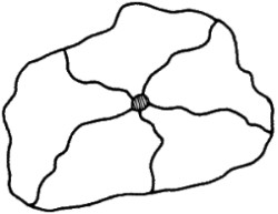
 Satellite Loop:
-
Use satellite loops to provide an even wider range of alternatives in terrain,
solitude, interpretive opportunities and user ability. The central loop
collects users allowing them to return to the trailhead.
 Spoked Wheel:
-
Use spoked wheels to offer a range of travel distance alternatives where
users may turn back to the trailhead from a number of different points.
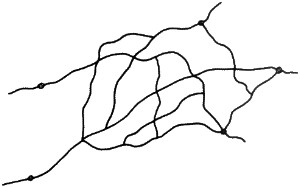
 Maze:
Maze:
-
Use a maze to make maximum use of an area by letting users explore their
own routes. A maze provides a variety of terrain conditions, travel distances
and interpretive themes. Mark such trails well, with directions and distances
to prevent users from becoming lost or over-extending themselves.
2.6.2 Assess Trail Route Alternatives
Once a general approach to trail layout is established, assess trail
route alternatives. Review topographic maps and air photos to select potential
trail corridors. Explore the site to find potential trail routes. Assess
the feasibility of the proposed trail. Identify any obstacles to trail
construction, for example poorly drained slopes or valley bottoms.
-
Plan the trail to a standard that will serve users well and minimize environmental
effects and maintenance.
-
Assess the length and difficulty of the proposed trail corridor(s).
-
Consider the type of user, seasonal-use, and special needs such as horse
hitches and wheel-chair access.
-
Plan to separate conflicting uses.
-
Assess water availability on the route.
-
Select trail routes that avoid critical seasonal wildlife habitat areas.
-
Avoid trail routes that cross hazardous rivers or creeks (unless bridges
are planned), avalanche or debris flow ones, or other terrain hazards.
-
Assess requirements for campsites, shelters or other services en route.
-
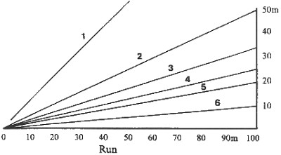
Determine the trail length depending on the type of trail activity, the
ability and interest level of the users and the terrain conditions of the
trail route. Plan trail difficulty by matching the type of use to proposed
trail gradients. Figure 1 shows various gradients by ratio, percentage
and degrees.
2.6.3 Assess Trail Route Gradients
Ease of travel along a trail is affected by the degree of slope, the
length of sustained grade and the proportion of uphill to downhill and
level sections along the trail. Plan for a level a-ail section at the end
of steep or sustained grades. Select variations in a-ail gradients with
gentler sections in between steep climbs. Avoid long, sustained grades.
Consider switchbacks, steps or ladders for small sections of very steep
slopes. For most trails, plan for a 20% maximum grade over a distance of
30 m. If only a few steep areas occur along the route, allow for greater
maximum grades as required.
Figure 1: Trail Gradients
| 1 |
1:1 |
100% |
45o |
| 2 |
1:2 |
50% |
27o |
| 3 |
1:3 |
33% |
18o |
| 4 |
1:4 |
25% |
14o |
| 5 |
1:5 |
20% |
11o |
| 6 |
1:10 |
10% |
6o |
|
 |
2.6.4 Estimate Parking and Service Needs
-
Trailheads and parking facilities are an essential part of trail planning.
Plan these facilities to reflect the trail character, the type of trail
activity, and the anticipated number of users. Consider en route and destination
service requirements when planning the trailhead facilities.
-
Advocate the trailhead(s) to optimize access and services.
-
If several trails are in the same area, locate the trailhead to provide
access to as many of these trails as possible. In cases where different
trails have different use requirements, such as for hikers and horse riders,
then consider separate trailhead and parking facilities.
-
Consider space requirements for larger vehicles, such as trailers or stock
trucks, and the safety of unattended vehicles.
-
Assess toilet and waste disposal requirements.
-
Consider snow removal and winter maintenance on winter access routes and
facilities.
2.6.5 Assess Trail Plan Impacts
-
After the preliminary planning steps, review the likely environmental change
to the area where the trail is proposed. Use the L.A.C. approach where
appropriate.
-
Assess the impacts of the proposed trail on park management, natural and
cultural resources, users and maintenance. Use the L.A.C. approach where
appropriate.
-
Modify the overall trail layout as required to minimize negative impacts
on the environment and expected users.
|