| 3.10 Prepare
Trail Design Drawings
Mark the
location of the trail on a prepared topographic base map of the trail area.
Use a scale of 1:50,000 as a bare minimum for longer backcountry trails,
use scales of 1:5,000 or better if possible. Where suitable map scales
are not available, consider using air photo enlargements to prepare trail
design plans.
-
Show specific
recreation and landscape features on the plans to assist the construction
team, but also to assist with interpretive planning.
-
Show the specific
location of all construction requirements, such as bridges, grade dips,
right-of-way clearing and switchbacks. Match these to distance markers
in the field.
-
Show trail
construction requirements as straight-line diagrams, log records, or notes
on the plan.
-
Include any
notations on environmental conditions and limitations to trail use, to
facilitate future design or construction changes.
Table 1 shows an example of a hypothetical construction log report.
Table
1 Construction Log - Black Tusk Trail
| Km + m |
Work Item |
Remarks |
| 0+0 |
begin project |
|
| 0+40+0+80 |
remove outslope |
|
| 1+50 |
sand and gravel site |
see map for borrow location |
| 2+80+3+10 |
install log rounds |
use local logs |
| 4 +00 |
grade dip |
|
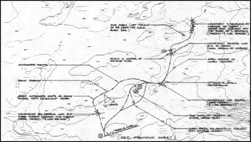
Figure 3 shows a
trail design drawing complete with construction
notes from Chilkoot Trail National Historic park.
|